
Azure Maps is a set of geospatial services and SDKs that employ real-time mapping data to provide online and mobile apps with a geographic perspective. In this blog post, we will go through Azure Maps pricing and features details.
Azure Maps Pricing And Feature
Offerings by Azure Maps:
- REST APIs for rendering vector and raster maps, as well as satellite images, in a variety of styles.
- Map creation and rendering services based on private interior map data.
- Addresses, locations, and points of interest can all be found using search engines all over the world.
- For applications that require real-time traffic data, there are two views: traffic flow and incidents.
- Geolocation and time zone services.
- Digital Elevation Model Elevation Services
- With location information hosted in Azure, a geofencing service, as well as mapping data storage, is available.

Azure Maps pricing structure is as follows-
Gen2 is Azure Maps’ latest pricing tier, which offers volume-based discounts on all map features. Users just have to pay for the services they really use. The following prices are per 1,000 transactions. For further information on Azure Maps price plans, customers adopting Azure through an Enterprise Agreement (EA) can utilize the Azure pricing calculator or checkup specifics on the EA portal.
| Not available | Not available | Free | Tier 0 | Tier 1 | Tier 2 | Tier 3 |
| Meters | <100K | <500K | <1M | 1M+ | ||
| Maps | Base Map Tiles | 5,000 | $4.50 | $3 | $1.50 | $0.50 |
| Imagery Tiles* | 1,000 | $5 | ||||
| Traffic Tiles | 5,000 | $4.50 | $3 | $1.50 | $0.50 | |
| Weather Tiles | 1,000 | $4.50 | $3 | $1.50 | $0.50 | |
| Static Map Images | 1,000 | $4.50 | $3 | $1.50 | $0.50 | |
| Location Insights | Data | 5,000 | $4.50 | $3 | $1.50 | $0.50 |
| Geolocation | 5,000 | $4.50 | $3 | $1.50 | $0.50 | |
| Elevation* | 1,000 | $5 | ||||
| Search | 5,000 | $4.50 | $3 | $1.50 | $0.50 | |
| Routing | 1,000 | $4.50 | $3 | $1.50 | $0.50 | |
| Spatial Calculations | 5,000 | $4.50 | $3 | $1.50 | $0.50 | |
| Time Zone | 5,000 | $4.50 | $3 | $1.50 | $0.50 | |
| Traffic | 1,000 | $4.50 | $3 | $1.50 | $0.50 | |
| Weather | 1,000 | $4.50 | $3 | $1.50 | $0.50 | |
| Not available | Service | Unit of measure | Price | Not available | ||
| Creator | Map provisioning | 1 storage unit per hour | $0.42 | Creator | ||
| Map render | 1k transactions | $0.20 | ||||
| Feature state | 1k transactions | $0.03 | ||||
| Web feature | 1k transactions | $21 |
Note on Transactions
One transaction is made for Base Maps, Imagery, Traffic, and Weather Tiles requests, with increments of 15 tile requests.
Each API call for Elevation multiple point requests qualifies as two Elevation transactions. One API tile request equals 50 Elevation transactions when it comes to bounding box requests.
For Route Matrix, each cell in the matrix counts as one transaction. There would be 50 Routing transactions if users provided 5 sources and 10 destinations.
Each query in a batch qualifies as a separate Search transaction when using Batch Search. Each route calculation query in a Batch Route call qualifies as a Routing transaction.
The pricing tiers work on a waterfall basis, which means that if a user hits a tier’s transaction ceiling, any subsequent transactions will be at the following tier’s rate. Volume discounts are not available for Imagery Tiles or Elevation APIs. The billing is done on a monthly basis.
Existing Azure Maps clients will be able to keep their Gen1 pricing, although users can change it at any time.
| Tier | Services offered | Use Case | Included free quantity | Queries Per Second (QPS) | Price beyond included free quantity (For Maps, Traffic & Weather Tiles) |
| Standard S0 | Map Render Search Route Traffic Time Zone Geolocation Weather | For small-scale deployments, customers requiring only the core geospatial APIs, and/or customers with small volumes of concurrent users | Maps and Traffic Tiles: 250,000 combined total transactions per month Weather Tiles: 5,000 transactions per month Time Zone Service: 5,000 transactions per month All Other Maps Services (excluding Weather Service): 25,000 combines total transactions per month | 50 QPS | $0.50 per 1,000 transactions |
| Standard S1 | Map Render: Includes Satellite Imagery Search: Includes Batch Search Route: Includes Batch Routing, Matrix Routing, Route Range (Isochrones), Traffic, Time Zone, Geolocation, Elevation, Spatial Operations(Including Geofencing), Azure Maps DataPREVIEW, Weather, Conversion, Dataset, Tileset, Feature Stat, and Web Feature | For customers who need support for large-scale enterprise, mission-critical applications, have high volumes of concurrent users, and/or require advanced geospatial services | Greater than 50 QPS | $5 per 1,000 transactions | |
| Standard S1 | Map Render: Includes Satellite Imagery Search: Includes Batch Search Route: Includes Batch Routing, Matrix Routing, Route Range (Isochrones), Traffic, Time Zone, Geolocation, Elevation, Spatial Operations (Including Geofencing), Azure Maps DataPREVIEW, Weather, Conversion, Dataset, Tileset, Feature Stat, and Web Feature | For customers who need support for large-scale enterprise, mission-critical applications, have high volumes of concurrent users, and/or require advanced geospatial services |
Core Features of Azure Maps:

Location Intelligence
Build IoT and AI solutions that are safe, adaptable, and offer dynamic, location-based services. Vehicle routing, traffic simulations, and asset tracking services, as well as POI data and satellite imagery analytics, are all possible with Azure Maps.
Mobility Technology
Numerous map layers, like heatmaps, picture layers, and HTML markers, can be used to manage and modify the data representations. Choose from a variety of imaging formats, such as satellite, grayscale, and shaded relief tiles.
Open Source
Create location-aware applications with a streamlined development process. Combine open-source and other map controls, such as OpenLayers, Leaflet, and Cesium, and also OGC standards like GeoJSON and KML, with ease.
Location-aware applications and It’s Use Cases:
Location-aware apps under the Azure Maps pricing model, not only provide retailers with very targeted marketing opportunities but also promote social connectivity and environmental consciousness by giving users a location-based filter for online data.
Browser plug-ins placed in gadgets like cellphones or any other Web-enabled devices could be used as location tools. To detect the user’s physical position, mobile phone towers, wireless connection points, GPS satellites, or a mixture of these can be employed. The physical placement of access points and cell towers is determined by the connectivity to an autonomous connection point. This data is subsequently integrated and logged into databases that are updated on a regular basis.
When a user opts for a location-based service on a suitable mobile phone, that information is provided to location-aware apps, which strive to present resources depending on the user’s current position. A location-aware program may share a user’s physical location with other location-aware or social networking apps. Users can specify which application should receive the data and how comprehensive the data should be, or they can simply enter the position parameters manually and bypass all the other data.
Some of the benefits of a location-aware application:
- Provides a cost-effective solution without the requirement for additional hardware such as that required for GPS-based systems.
- Provides location awareness inside buildings or in regions where GPS isn’t available.
- Allows users to define user-specific places, allowing them to create a fully customized map.
Location-aware applications can be useful in a variety of situations, including but not restricted to:
- Tourism
- Electronic queuing
- Locating the nearest point of interest
- Locating the nearest social media contact
Building Location-based Intelligent Apps for IoT devices

Developing a location-based app is a multi-stage process that includes testing, analysis, wireframing, and customer engagement. This well-organized procedure focuses on discovering the key variables that allow a company to sustain market leadership.
Some of the most important considerations and procedures in developing a location-based app are:
Step 1: Investigate Your Concept
The business analysis provides information on current customer behavior that should be taken into account when designing an app. Also, use a story map to organize each discovery by priority and complexity.
In all, conduct market research and competitive analysis to assess market potential and determine how to improve the app.
Step 2. Create a Wireframe of your geolocation app
Location-based app development necessitates UX app design and wireframing. Before the program enters the development stage, one should constantly envision it on a screen and correct any potential functioning difficulties.
Step 3. Prove GPS app concept with MVP
For designing location-based applications, a proof of concept (MVP) is required. This proof of concept shows that the application has the potential to be a successful product.
Step 4. Create a feature-rich map-based app
Following customer input, one can move on to the next stage of development and add more crucial features to the app. Pay close attention to customer complaints and ideas at all times.
The major features of location-based apps should always deliver the best advice on things within a specific radius.
Spatial analytics and Azure Maps:
The accumulation, display, and modification of location-based data—or geodata—such as street names, zip codes, satellite pictures, and GPS coordinates—is referred to as spatial analysis. The spatial Analysis feature under Azure Maps pricing structure helps you discover location-based findings by overlaying maps with layers of location and business information as sales statistics or transit times—so you can visualize, analyze, and gain a more holistic perspective of your data.
The Azure Maps Spatial service evaluates location data quickly to keep clients up to date on current events. It enables event analysis and predictive modeling in near-real-time.
Key Features of Azure Map:
Data service
Bringing client data proximate to the Azure Maps service reduces latency, improves productivity, and expands your application’s possibilities.
Geolocation service
To find out what country or region an IP address belongs to, use the Geolocation service. This service can assist you to improve the user experience by offering geo-targeted application content.
Render service
The Get Map Tile V2 API has been updated in the Render service V2. Users can now use the Get Map Tile V2 API to retrieve Azure Maps Road tiles, climate tiles, or map tiles generated with Azure Maps Creator.
Route service

For each specified route, the route capabilities under Azure Maps pricing plans can be used to determine estimated arrival times (ETAs). Route APIs take into account real-time and historical traffic data, as well as typical road speeds for the desired day of the week and time of day. The APIs return the quickest or shortest routes available to several locations at the same time, in terms of time or distance, in sequence or in optimized order.
Developers can use the service to generate directions for a variety of forms of transportation, including cars, trucks, bicycles, walking, and electric vehicle. Inputs such as departure time, weight limitations, and hazardous item transit are also taken into account by the service.
The Route service has a number of sophisticated set features, including:
- Handling several route requests in a batch.
- Time and distance grids between a subset of origins and endpoints.
- Identifying routes or distances that users can travel depending on their time or fuel needs.

Search service
Developers can use the Search service to look up addresses, locations, business listings via name or type, and other geographic data. In addition, based on latitudes and longitudes, services can reverse geocode addresses or crossroads.
The complex features of the Search service include:
- Looking for clues along a path.
- Expanding your search to include a larger area.
- Creating a batch of search queries.
- Using the brand name to find electric vehicle charging stations and Points of Interest (POI) info.

Spatial service
The Spatial service analyzes location data fast to help clients stay informed about ongoing occurrences in time and space. It allows for near-real-time event analysis and prediction modeling.
Customers can leverage a library of basic geospatial mathematical formulas to improve their location intelligence. The nearest point, great circle distance, and buffers are all typical computations.
Time zone service
Anyone can use the Time Zone service to look for the present, historical, and upcoming time zones. As an input, you can utilize either longitude and latitude coordinates or an IANA ID.
- Transforming Microsoft Windows time-zone IDs to IANA time zones is also possible with the Time Zone service.
- Obtaining a UTC time-zone offset.
- Obtaining the current time in a specific time zone.
Weather services
Developers can utilize APIs provided by weather services to access weather data for a specific place. The data includes information such as the date and time of the observation, a short description of the weather conditions, a weather icon, precipitation indication flags, temperatures, and wind speed.
The Get Weather Along Route API allows developers to get atmospheric information for a specific route. The service under Azure Maps pricing, also allows users to create weather alerts for waypoints that are impacted by weather threats like floods or heavy downpours.
Traffic service
The Traffic service is a set of web services that developers can utilize to create traffic-related online or mobile applications. There are two sorts of data available through the service:
- Traffic flow: Speeds and commute times for all major routes in the network as seen in real-time.
- Traffic incidents: Get the most up-to-date information on traffic bottlenecks and events on the road network.
Elevation service
The Azure Maps Elevation service is a web service that allows developers to access elevation data from just about any location on the globe.
Users can get elevation data in two formats using the Elevation service:
- GeoTIFF raster format.
- GeoJSON format.
Security Features in Azure Maps for keeping Geo Locations safe:
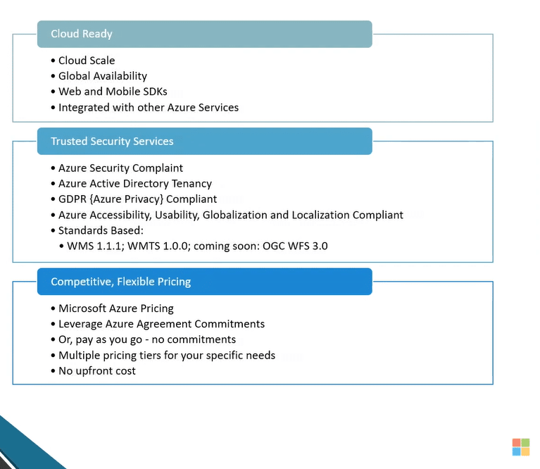
- With built-in Azure Active Directory authentication & role-based access management, users can get Azure security and scale (RBAC).
- Improve data privacy and security by adhering to the General Data Protection Regulation (GDPR).
- Microsoft has over 3500 security specialists dedicated solely to protecting your gaming data and privacy.
EPCGroup Azure Consulting services: Azure Maps
EPC Group gives a new depth to the phrase Azure managed service provider with a comprehensive set of capabilities from Microsoft. They are a Microsoft gold certified partner, committed to removing operational barriers so that their clients may concentrate on revenue-generating initiatives.
Conclusion:
In conclusion, Azure map is a fantastic service offered by Microsoft Azure. It is a combination of geospatial services and SDKs that use real-time mapping information to deliver a geographical viewpoint to online and mobile projects. In addition, if you want to be competitive in the current market, it’s crucial to comprehend and make the most of your data. Data Architecture Consulting services offer a means to analyze your data.